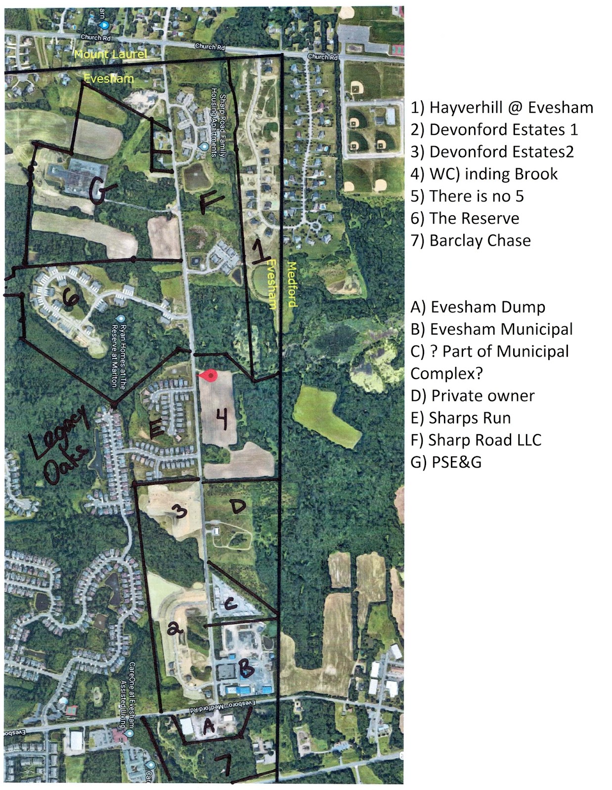
(This was my attempt to hand-draw property lines and separations between neighborhoods. These are not exact. Don't place any stock in the lines I have drawn or ownership of any properties.)
A few weeks back, I was driving down Route 70 and saw a lot of construction going on in what was previously a wooded lot. The lot in question was the property that surrounds the town transfer station (AKA the dump), soon to be home of Barclay Chase. After posting some photos on Facebook, quite a few people suggested driving down Sharp Road and seeing all the new construction.
While I have lived in town for 14 years, I have only been down Sharp Road a couple of times - I think there was briefly some construction going on and I needed to detour down Sharp Road to get to the Medford Ice Risk (which sadly no longer exists). So it had probably been around 8 years since I've been down that way, despite living only about a mile away. If you don't live off Sharp Road, there really isn't a need to drive down it.
Before setting out for Sharp Road, I looked at it on Google Maps and at NJParcels.com. Google Maps gives shows you exactly what it looks like and NJParcels.com will show you the size, shape, and owners of properties. The map above is my attempt to combine the two. I am map addict, so mapping out exactly who owns what, where borders are and where future roads and developments might go was quite enjoyable.
What follows is my experience of Sharp Road. Unlike some previous blog entries, I don't see this stirring up a lot of conversation as I don't think this is a controversial subject. If it does stir up something for you, I would ask that if you are going to make comment on any neighborhoods mentioned, please remember your friends and neighbors live there. These are their dream homes.
Sharp Road is about 1.4 miles from the town dump to Church Road in Mount Laurel, a stone's throw from Lenape High School. It ends near where Medford, Mount Laurel and Marlton all meet. The photo above from Google Maps is probably a couple of years old, based on what is and isn't on the map. The road is one lane in each direction, with no traffic lights or stop signs. It would appear that it can be widened to 2 lanes in each direction should that ever be needed.
All the numbered plots are 'new' neighborhoods, built since 2015. I knew nothing about these neighborhoods, having only seen their names on demographic reports for Evesham Township School District enrollment calculations. The lettered plots are either older neighborhoods or 'other' things.
Hayverhill at Evesham

While not on Sharp Road, I decided to include Hayverhill at Evesham (marked #1 on the map) just because of its proximity and because I found its features on the map interesting. The Hayverhill neighborhood consists of just one road in a horseshoe shape (plus a small cul-de-sac). The horseshoe, however is divided in half by the town line, so half the homes are in Hayverhill at Evesham, the other half are in Hayverhill at Medford. So your children may go to a different school than your next door neighbors.
I have indicated the approximate town line below in yellow. What I find interesting is if you look at the brown space between the houses on either side of the border, it would appear to be wide enough to pave a road there. More on that later.


A few other oddities regarding the neighborhood. When you exit the neighborhood from the Marlton side, you will be in Mount Laurel. While you may have an identical house to your neighbor and buy at the exact same price, your taxes could be different, depending on which township you are in. Your older children may have a 20 minute bus ride to Shawnee or a 15 minute bus ride to Cherokee. No one gets the 5 minute walk to Lenape, which is in Medford, just on the other side of Church Road (shown below). Medford students go to Shawnee.

As shown in the photo at the top of this blog, there is quite a bit more land at the bottom of the horseshoe owned by the same developer in plot #1, which is still undeveloped. I don't know whether there are future plans to build more houses, but it is always a possibility Maybe a new road between the two houses I mentioned above? Or the developer still owns alot of land just over the Medford border, so a road could come from there back into Marlton? Or perhaps a road can come directly fro Sharp Road at some time in the future.
The Reserve at Marlton

Turning onto Sharp Road from Church Road, the first new neighborhood you get to will be on your right called The Reserve at Marlton, marked #6 on the map. The Reserve began construction in 2015 and contains (I believe) 97 townhomes. It would appear that every home is currently occupied. The construction must have been completed fairly recently, as the sewers and manholes still protrude from the street and are marked by traffic cones. The roads still need another coat of asphalt.
They were first announced in 2014.


And like Hayverhill mentioned above, the developer owns quite a bit of additional land in plot #6 on the photo at the top of the blog.
Windingbrook
Just down Sharp Road from The Reserve is the future home of Windingbrook.

Aside from the development office shown above, there is nothing on the site except construction equipment.


When completed, the neighborhood will contain 60 townhouses, starting from the $300s. I believe this is the same price range as The Reserve. Since the Reserve has sold out, it would appear these will be popular as well. The neighborhood will have two roads exiting to Sharp Road.

The townhouses will look like this:

Devorforde Estates

Devonforde Estates will contain 57 3-4 bedroom single family homes. Estates I (marked #2 on the map) appears to be completed. That is the horseshoe shaped road across the street from the new municipal building on Sharp Road. Estates II is still under construction, though some houses have been completed, marked #3 on the map. It would also appear there is room between Estates I and II for additional houses.


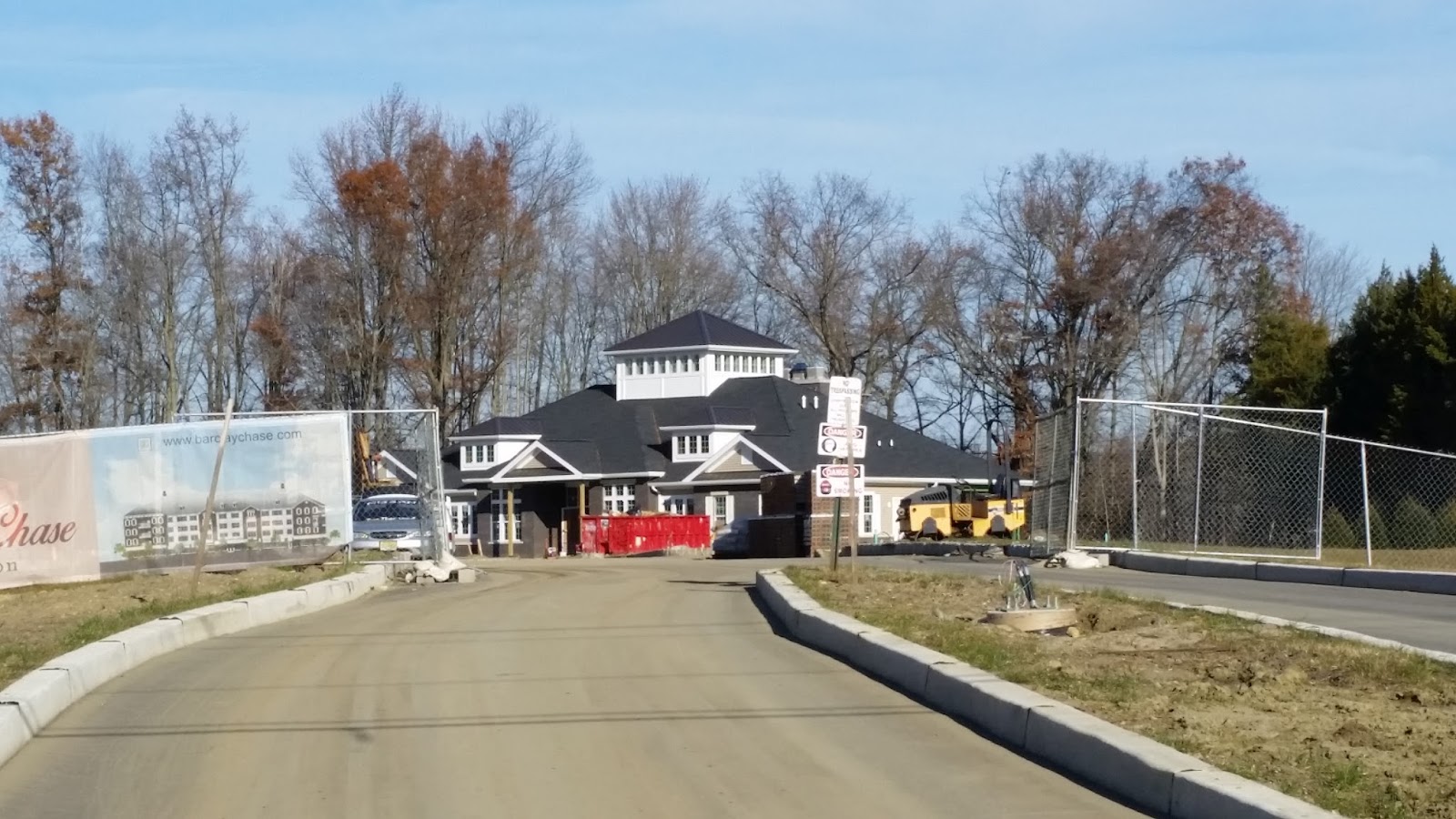
Barclay Chase
Barclay Chase surrounds the current Evesham Transfer/Recycling Station and is marked #7 on the map. There will be exits on Evesboro Medford Road and to Route 70. Phil Warren has already written a good summary of this construction. There will be 7 apartment buildings that will look essentially like this:

The exit on to Route 70 is concerning, as there is nothing preventing a left turn. That stretch of Route 70 has seen its share of fatal accident over the years. I'm hoping that at some point the exit will be modified to prevent left turns. If you want to get on Route 70 E, you'll have to exit out the Evesboro-Medford Road side and make a right towards Medford. The other solution would be adding a traffic light there, although I don't think many people will be in favor of that.

Here are pictures from the Route 70 side. There's not much to see from the Evesboro Medford Road side yet.

That is all for the new developments on Sharp Road. Here is what else is on the road.
Evesham Township Public Works Department
Marked 'A' on the map, it is alternately known as 'The Dump', the 'Transfer Station', the 'Recycling Station'. My journey down Sharp Road actually began there. Seeing as it was the first Saturday of the month, that is paint drop off day and I had about 15 years worth of miscellaneous paint to drop off. I probably go to the dump half a dozen times a year, and each and every time, all the employees are always so friendly and helpful. This time was no exception. Somehow I ended up covered in blue paint (through my own negligence), and the gentleman in the paint collection area was very helpful in locating rags for me to clean myself with. I really should have gotten a picture of that - I apologize I neglected that. I must say, however, that blue looks good on me.
Evesham Municipal Services Complex
Marked 'B' on the map, this is the site of the former Lipinski's and is now the home of the MUA and other town services. The transfer station will be relocating there at some point as well.

C
I do not know what C is. It is filled with trucks and busses, but no indication as to whose they are. Its possible they are town vehicles.
Ellis Superfund Site

Marked 'D' on the map, the Ellis Superfund site is 36 acres in Marlton and Medford currently being remediated by the EPA. There was soil and groundwater contamination back in the 1970s.
Its current status according to the EPA is: "Design of the remedy was completed in 2015. Implementation of the cleanup is PENDING UNTIL FUNDED." (emphasis added)
Other things:
E on the map is Sharps Run, built in 2009.
F is owned by Sharp's Road LLC, including Sharp Road Family Housing. There seems to be quite a bit of unused land.
G is owned by PSE&G.
Final Thoughts:
New development is a natural part of the growth of any city. Development by its nature is not a bad thing. Some development is good for a town. Other development may lead to overcrowding, traffic and parking issues.
Before I wrote this, I looked at a time lapse of the development of Marlton, brought to you buy Google Earth. It is easy and natural for people to lament the sleepy town they once knew, but is now no more. It was interesting for me to see Marlton before Country Farms (where I current live). Country Farms has been here 30 years, so no one is complaining about the 'new' development. But back in 1984, the loss of the farmlands was surely the cause of an outcry.
It should be noted that just east of Barclay Chase, Medford has announced plan for a new development of their own. And the overhead map shows that the area still has a lot of undeveloped land, so we will probably see more.